News
DEEPVIEW Project website is on
17 June 2026
The DEEPVIEW Project website is on: "DEEPVIEW – Coastal Depth Estimation Platform and Virtual Environment".
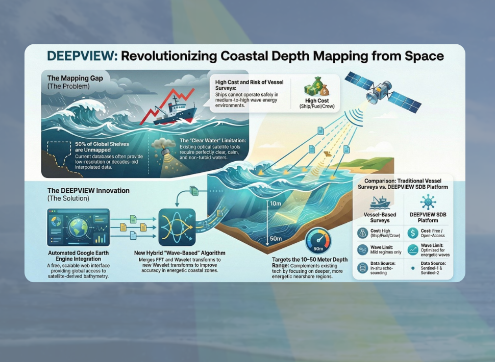
Coastal bathymetry is traditionally obtained from in-situ ship-surveys, which involves high costs and is often subject to operational and safety restrictions in the nearshore. Vessels cannot operate under medium to high wave energy periods, leading surveys to be mainly carried on under mild conditions.
To address those limitations and costs, the DEEPVIEW project aims to develop a wave-based Satellite-Derived Bathymetry (SDB) algorithm, capable of measuring sea-surface waves from space. Based on physical sea-wave propagation laws, the goal is to estimate bathymetries for depths between 10 to 50 meters, especially in energetic wave regions.
The project also proposes an automated cloud-based service using Google Earth Engine (GEE), providing immediate online access to the SDB data from Sentinel-1 and Sentinel-2. This tool will support research, industry, and coastal management, enabling applications in climate change, coastal dynamics, marine energy, aquaculture, risk analysis, and navigation.
This work is funded by national funds through the FCT – Foundation for Science and Technology, I.P., as part of the project no. 2023.16569.ICDT. It is expected to contribute to the following SDG goals: 7 - Affordable and Clean Energy; 9 - Industry, Innovation and Infrastructures; 11 - Sustainable Cities and Communities; 13 - Climate Action and 14 - Life Below Water. The two partners, LNEC and ISEP, bring in and combine expertise in remote sensing, ocean wave mechanics, image processing and cloud platforms. LNEC is the project coordinator.