ENGENHARIA PARA A SOCIEDADE
Laboratory of Digital Image Processing
Laboratory of Digital Image Processing
Laboratory of Digital Image Processing
Laboratory of Digital Image Processing
Laboratory of Digital Image Processing
Laboratory of Digital Image Processing
LabImagem
LabImagem
LabImagem - Laboratory of Digital Image Processing is a research unit created at the Applied Geodesy Division of LNEC´s Concrete Dams Department, whose goal is to provide consultancy in the application of digital image processing techniques (DIP) to Civil Engineering and on the subject of production, use and exploitation of geographic information (Cartography and GIS).
Activity areas
The following areas of study are developed at LabImagem on the scope of projects INFRASAR and ImEngine:
- Application of DIP to the administration of the territory, including processing of satellite optical and SAR images, namely Landsat, SPOT, IKONOS, WorldView, ERS, Envisat, etc., using pattern recognition methods to extract information about land cover/use for decision support systems (GEOSAT, RIVERSAR);
- Application of RADAR interferometry with permanent scatterers (PSINSAR) for detection of displacements on infrastructures (buildings, dams, slopes);
- Application of DPI techniques to the detection and survey of pathologies in engineering structures, through the processing of photographs obtained in inspection campaigns: construction of orthophotos and mosaics for general and detailed analysis of the structure;
- Detection of movements in slopes located in construction sites, through photographs acquired at different times;
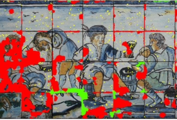
- Preparation of the Graphic Register of Damage of tiled facades on buildings and figurative panels, for planning of conservation and restoration actions;
- Monitoring of pathologies evolution;
- Evaluation of the photographs acquired by unmanned aerial vehicles (UAV) for inspection of engineering structures
Testing
Other services