 Scientific Instrumentation Centre
Information Technology and Computer Infrastructures Unit
Publications
|
Papers
Info
Deep Learning-Based River Flow Forecasting with MLPs: Comparative Exploratory Analysis Applied to the Tejo and the Mondego Rivers

Abstract: This paper presents an innovative service for river flow forecasting and its demonstration in two dam-controlled rivers in Portugal, Tejo, and Mondego rivers, based on using Multilayer Perceptron (MLP) models to predict and forecast river flow. The main goal is to create and improve AI models that operate as remote services, providing precise and timely river flow predictions for the next 3 days. This paper examines the use of MLP architectures to predict river discharge using comprehensive hydrological data from Portugal
Year: 2025
Number Pages:
27p..
Author(s): Jesus, G.; Korani, Z.; Alves, E.; Oliveira, A.
: MDPI Journal (Sensors)
Editor: MDPI
Volume:
Revista Sensors.
Keywords: SNIRH; MLP;; Deep learning;; Artificial intelligence;; River flow forecasting;
Info
Guiding Evacuees to Improve Fire Building Evacuation Efficiency: Hazard and Congestion Models to Support Decision Making by a Context-Aware Recommender System
Abstract: Fires in large buildings can have tragic consequences, including the loss of human lives.Despite the advancements in building construction and fire safety technologies, the unpredictablenature of fires, particularly in large buildings, remains an enormous challenge. Acknowledging theparamount importance of prioritising human safety, the academic community has been focusingconsistently on enhancing the efficiency of building evacuation. While previous studies have inte-grated evacuation simulation models, aiding in aspects such as the design of evacuation routes andemergency signalling, modelling human behaviour during a fire emergency remains challenging dueto cognitive complexities. Moreover, behavioural differences from country to country add anotherlayer of complexity, hindering the creation of a universal behaviour model. Instead of centring onmodelling the occupant behaviour, this paper proposes an innovative approach aimed at enhancingthe occupants
Year: 2023
Number Pages:
22p.
Author(s): Neto, J.; Morais, A.J.; Gonçalves, R.; Leça Coelho, A.
: Journal MDPI
Editor: https://www.mdpi.com/journal/buildings
Volume:
Buildings 2023, 13, 3038.
Keywords: context-aware recommender system; multi-agent recommender system; building evacuation efficiency; Internet of Things; human behaviour; fire building evacuation
Info
Model-driven engineering techniques and tools for machine learning-enabled IoT applications: a scoping review
This paper reviews the literature on model-driven engineering (MDE) tools and languages for the internet of things (IoT). Due to the abundance of big data in the IoT, data analytics and machine learning (DAML) techniques play a key role in providing smart IoT applications. In particular, since a significant portion of the IoT data is sequential time series data, such as sensor data, time series analysis techniques are required. Therefore, IoT modeling languages and tools are expected to support DAML methods, including time series analysis techniques, out of the box. In this paper, we study and classify prior work in the literature through the mentioned lens and following the scoping review approach. Hence, the key underlying research questions are what MDE approaches, tools, and languages have been proposed and which ones have supported DAML techniques at the modeling level and in the scope of smart IoT services.
Year: 2023
Number Pages:
27p.
Author(s): Korani, Z.; Moin, A.; Silva, A.; Ferreira, J.
: Sensors
Editor: MDPI
Volume:
Volume 23, Issue 3.
Keywords: scoping review; literature review; time series; data analytics and machine learning; internet of things; model-driven engineering
Info
Context-Based Multi-Agent Recommender System, Supported on IoT, for Guiding the Occupants of a Building in Case of a Fire
Abstract: The evacuation of buildings in case of fire is a sensitive issue for civil society that alsomotivates the academic community to develop and study solutions to improve the efficiency ofevacuating these spaces. The study of human behavior in fire emergencies has been one of the areasthat have deserved the attention of researchers. However, this modeling of human behavior is difficultand complex because it depends on factors that are difficult to know and that vary from countryto country. In this paper, a paradigm shift is proposed which, instead of focusing on modeling thebehavior of occupants, focuses on conditioning this behavior by providing real-time information onthe most efficient evacuation routes. Making this information available to occupants is possible witha solution that takes advantage of the growing use of the IoT (Internet of Things) in buildings to helpoccupants adapt to the environment. Supported by the IoT, multi-agent recommender systems canhelp users to adapt to the environment and provide the occupants with the most efficient evacuationroutes. This paradigm shift is achieved through a context-based multi-agent recommender systembased on contextual data obtained from IoT devices, which recommends the most efficient evacuationroutes at any given time. The obtained results suggest that the proposed solution can improve theefficiency of evacuating buildings in the event of a fire; for a scenario with two hundred peoplefollowing the system recommendations, the time they take to reach a safe place decreases by 17.7%.
Year: 2022
Number Pages:
30pp.
Author(s): Neto, J.; Morais, A.J.; Gonçalves, R.; Leça Coelho, A.
: Journal Electronics (https://www.mdpi.com/journal/electronics)
Editor: MDPI
Volume:
Electronics 2022, 11, 3466..
Keywords: building occupant guidance; occupant behavior conditioning; ontologies; fire building evacuation; IoT
Info
Enhancing a coastal territorial vulnerability index: anticipating the impacts of coastal flooding with a local scale approach
The coastal zone of mainland Portugal is characterized by its morpho-sedimentary diversity such as estuaries, lagoons, barrier islands, beaches, dunes and cliffs. The high population density and the multiplicity of land use, occupation and activities, makes it an area of great national strategic value. This transforms the coastal zone into a multi-hazard zone, where the occurrences related to coastal flooding and overtopping stand out. In the present work, a multidi mensional methodology called Coastal Territorial Vulnerability Index (CTVI) was developed and applied in three selected areas with a historical record of coastal impacts, to analyze, evaluate and interpret the local vulnerability. The methodology considers four components of coastal territorial vulnerability: morphology, land value, buildings and public areas characteristics. These four components are combined to calculate the CTVI. The results highlight the differences for the analyzed areas, allowing the differentiation of natural and artificial areas. In the natural areas a moderate CTVI predominates, while in the latter, a high and very high CTVI stands out. The results contribute to the development of a comprehensive coastal flood risk assessment and forecasting the impacts
Year: 2022
Number Pages:
442-468pp..
Author(s): Barros, J.; Tavares, A.; Santos, P.; Freire, P.
: Coastal Management
Editor: Taylor & Francis
Volume:
50:5.
Keywords: multidimensional methodology; Vulnerability Index; Coastal Territorial; Vulnerability; Coastal Flooding; Coastal zone
Info
Multispectral Optical Remote Sensing for Water-Leak Detection
Water losses from water distribution means have a high environmental impact in termsof natural resource depletion (water, energy, ecosystems). This work aims to develop an opticalairborne surveillance service for the detection of water leaks (WADI
Year: 2022
Number Pages:
30p.
Author(s): Krapez, J.-C.; Sanchis Muñoz J; Mazel, C.; Chatelard, C; Déliot, P.; Frédéric, Y.-M.; Barillot,P.; Hélias, F.; Barba Polo J; Olichon,V.; Serra, G.; Brignolles, C.; Carvalho, A.; Carreira, D.; Oliveira
: Sensors
Editor: MPDI
Volume:
22(3), Special Issue Remote Sensing for Forecasting and Monitoring Aquatic Systems.
Keywords: thermal; evaporation; soil moisture; Trapezoid Method;; Triangle Method;; infrared; water leak;; remote sensing
Info
An Ontology for Fire Building Evacuation
Guiding the building occupants under fire emergency to a safe place is an open research problem. Finding solutions to address the problem requires a perfect knowledge of the fire building evacuation domain. The use of ontologies to model knowledge of a domain allows a common and shared understanding of that domain, between people and heterogeneous systems. This paper presents an ontology that aims to build a knowledge model to better understand the referred domain and to help develop more capable building evacuation solutions and systems. The herein proposed ontology considers the different variables and actors involved in the fire building evacuation process. We followed the Methontology methodology for its developing, and we present all the development steps, from the specification to its implementation with the Protégé tool.
Year: 2021
Number Pages:
pp 975-985.
Author(s): Neto, J.; Morais, A.J.; Gonçalves, R.; Leça Coelho, A.
: Lecture Notes in Networks and Systems book series (LNNS)
Editor: Proceedings of Sixth International Congress on Information and Communication Technology
Volume:
216.
Keywords: Knowledge representation; Ontologies; Fire emergency; Ontology development; Knowledge model; Ontology; Fire building evacuation
Info
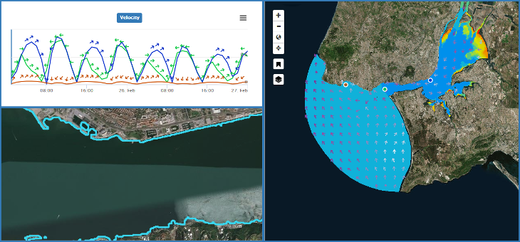
Forecasting contrasting coastal and estuarine hydrodynamics with OPENCoastS
Robust and accurate coastal forecasts require models to represent the relevant processes, prediction computa-tional tools and reliable computational resources. OPENCoastS is a free, open-source WebGIS platform to develop on-demand hydrodynamic forecast systems that started as a simple 2D engine. OPENCoastS provides a visuali-zation and download interface with in-situ and Sentinel satellite data comparison. 2D tidal, 2D wave & current interaction and 3D baroclinic flows are now included, forced by several atmospheric, oceanic and riverine forcings. Four applications demonstrate OPENCoastS
Year: 2021
Number Pages:
--.
Author(s): Oliveira, A.; Fortunato, A. B.; Rodrigues, M.; Azevedo, A.; Rogeiro, J.; Bernardo, S.; Lauvaud, L.; Bertin, X.; Nahon, A.; Jesus, G.; Rocha, M.; Lopes, P.
: Environmental Modelling and Software
Editor: Elsevier
Volume:
143 (não tem número).
Keywords: Baroclinic modeling; Wave and currents modeling; EOSC; Cross-scale; Unstructured grids; SCHISM; Forecast systems
Info
Multi-Agent-Based Recommender Systems: A Literature Review
Considering the growing volume of information and services available on the web, it has become essential to provide websites and applications with tools, such as recommender systems, capable of helping users to obtain the information and services appropriate to their interests. Due to the complexity of web adaptation and the ability of multi-agent systems to deal with complex problems, the use of multi-agent approaches in recommender systems has been increasing. In the present work, we make a thorough review of the use of multi-agent-based recommender systems. The review shows the diversity of applications of multi-agent systems in recommender systems, namely on what concerns the diversity of domains, different types of approaches and contribution to the performance improvement of the recommender systems.
Year: 2021
Number Pages:
pp 543-555.
Author(s): Neto, J.; Morais, A.J.; Gonçalves, R.; Leça Coelho, A.
: Lecture Notes in Networks and Systems book series (LNNS)
Editor: Proceedings of Sixth International Congress on Information and Communication Technology
Volume:
235.
Keywords: State-of-the-art; Literature review; Survey; Multi-agent systems; Recommender systems
Info
Multi-Hazard WebGIS Platform for Coastal Regions
The combined action of waves, surges and tides can cause flooding, erosion and dune andstructure overtopping in many coastal regions. Addressing emergency and risk management in theseareas require a combination of targeted campaigns and real-time data that measure all phenomena atstake and can be used to develop comprehensive monitoring platforms. These monitoring platformscan support the development of prediction tools that address all hazards in an integrated way. Herein,we present a methodology focused on multi-hazard coastal alert and risk, and its implementation in atailoredWebGIS platform. The MOSAIC platform offers a one-stop-shop capacity to access in-situ andremote sensing data, and hydrodynamic and morphodynamic predictions, supported by numericalmodels: SCHISM and XBeach. Information is structured on a local observatory scale, with regionalforcings available for the correct interpretation of local hazards effects. This implementation can befurther applied and extended to other coastal zones. The MOSAIC platform also provides access to adetailed database of past hazardous events, organized along several risk indicators, for the westerncoast of Portugal. The combination of features in the platform provides a unique repository of hazardinformation to support end-users for both emergency and long term risk planning actions.
Year: 2021
Number Pages:
16p.
Author(s): Rocha, M.; Oliveira, A.; Freire, P.; Fortunato, A. B.; Nahon, A.; Barros, J.; Azevedo, A.; Oliveira , F.; Rogeiro, J.; Jesus, G.; Martins, R.; Silva-Santos, P. M.; Tavares, A.; Oliveira, J. N.
: MDPI
Editor: Applied Sciences
Keywords: observatories; GIS; forecast systems; remote sensing; hydro-morphodynamic modeling; flood and erosion risk management; web platform
|
|
Comunicação
Info
SI-GeA - sistema de previsão em tempo real do desempenho das infraestruturas e da dinâmica dos meios recetores
No âmbito do projeto de I&D SI-GeA - Sistema Inteligente de Apoio à Gestão Avançada deSistemas Urbanos de Águas Residuais (QREN), está a ser desenvolvido um sistema inteligente deinterface para supervisão e apoio à decisão em tempo real de toda a informação relevante para a gestãode sistemas urbanos de águas residuais e pluviais, incluindo coletores gravíticos, sistemas elevatórios eestações de tratamento, proveniente de redes de monitorização, dados de operação das redes e desistemas de previsão em tempo real do comportamento das infraestruturas e meios recetores. Estesistema, que é baseado no sistema XHQ (SIEMENS - Oil & Gas
Year: 2014
Number Pages:
20 pp.
Author(s): David, C.; Póvoa, P.; Oliveira, A.; David, L. M.; Rodrigues, M.; Santos, J.; Matos, R.; Ferreira, F.; Matos, J. S.; Jesus, G.; Costa, J.; Rogeiro, J.; Mota, T.
Keywords: Modelação integrada; Sistemas inteligentes de apoio à gestão; Monitorização em tempo real; Previsão em tempo real; Gestão de sistemas de drenagem
Info
Validação do potencial de utilização de informação geográfica produzida voluntariamente para a análise espacial de percursos de transportes públicos em Lisboa
A Autoridade Metropolitana de Transportes de Lisboa (AMTL) tem como objetivo tornar o sistema de transportes da Área Metropolitana de Lisboa mais sustentável do ponto de vista social, ambiental, económico e financeiro. Para cumprir estes desígnios regista e analisa diariamente os dados sobre reconhecimento de títulos de transporte, bem como a adequabilidade das carreiras dos operadores de transportes públicos em termos de distâncias, paragens e interfaces com vista a incrementar a interoperabilidade e a intermodalidade.Para cumprir com êxito a análise de adequabilidade dos procedimentos dos operadores a AMTL tem de dispor de informação de qualidade, atualizada e devidamente estruturada, nomeadamente no que respeita à rede de estradas. Os dados com estas características são normalmente de difícil levantamento e atualização, pelo que implicam frequentemente custos significativos de aquisição ou de manutenção por via licenças de utilização.O artigo expõe um estudo sobre a qualidade dos dados geográficos sobre rede viária produzida por mecanismos crowdsourcing, nomeadamente o usado pelo OpenStreetMap (OSM-Wiki, 2014), um dos mais populares projetos de produção e partilha de informação geográfica a nível mundial. São analisados elementos de qualidade relativos à rede viária disponível no OSM, em Lisboa, por comparação com produtos geográficos comerciais e oficiais.Em todo o estudo privilegiou-se a utilização de software e dados de licença aberta, sendo no entanto pontualmente indicada a utilização de software comercial quando tal é considerado útil/necessário. São feitas análises comparativas entre algumas fontes de dados de forma a avaliar, para alguns cenários, a utilidade das diversas fontes de informação.
Year: 2014
Number Pages:
11 pp.
Author(s): Charneca, N.; Costa, J.
Keywords: Informação geográfica de produção voluntária; Infraestrutura rodoviária; Elementos de qualidade de dados geográficos
Info
VPlan
The reproducibility of modern research depends on the possibility to faithfully rerun the complex and distributed data transformation processes which were executed by scientists in order to make new scientific breakthroughs. New methods and frameworks try to address this problem by collecting evidence used for verification of such experiments. However, there is still a lack of a flexible data model which would address all of the needs of these methods. This paper presents the VPlan ontology designed for the purpose of organizing and storing of data collected for verification of preserved processes. The VPlan ontology stores and links the data extracted from the preserved process. Furthermore, it includes descriptions of actions taken to collect the data, as well as provides a clear break down of requirements that lead to its collection. We demonstrate the usage of the VPlan ontology within the preservation process and describe in detail itsalignment with the Verification Framework (VFramework). In order to illustrate its applicability to the eScience domain, we evaluate it on a use case from the civil engineering domain, which is an example of a typical sensor data analysis process.
Year: 2014
Number Pages:
10pp.
Author(s): Miksa, T.; Vieira, R. J. C.; Barateiro, J.; Rauber, A.
Keywords: Context model; Process modelling; Ontology; Verification
Info
Framework for Verification of Preserved and Redeployed Processes
Preserving processes requires not only the identification of all process components, but also the interception of all interactions of the process with the external influencers. In order to verify if the collected data is sufficient for the purpose of redeployment, as well as to verify that the redeployed process performs according to expectations, a framework for verification is needed. This paper presents a framework for verification of preserved and redeployed processes. We demonstrate the applicability of the framework on an use case from the eScience domain. The preservation and the redeployment of the eScience process is tested by migrating it to substantially different environments.
Year: 2013
Number Pages:
10pp.
Author(s): Miksa, T.; Pröll, S.; Mayer, R.; Strodl, S.; Vieira, R. J. C.; Barateiro, J.; Rauber, A.
Editor: BNP
Keywords: Ontology; Verification; Business processes
Info
From a nowcast-forecast information system to an oil spill risk assessment and response tool
This paper presents a custom developed WebGIS tool tailored for oil spill risk assessment and emergency response in coastal areas, built on a nowcast-forecast information system. The latter system was based on the custom deployment of a generic forecasting platform that integrates a suite of forecast models, as well as on the recent improvement in the models outputs visualization. Further developments have been made to support real-time monitoring through remote sensors and automatic comparison between data and model predictions. The system has now evolved to an integrated system that can assist in oil spills risk assessment and the rapid response to a possible emergency, as oil spills can have catastrophic effects both social-economic and environmental, endangering the sustainability and development of the coastal regions affected. The tool presented herein addresses the oil spills problem in two ways: a detailed risk assessment through risk maps and georeferenced information related with coastal areas, ports and estuaries to support the prevention and mitigation of accidents; and the visualization of georeferenced oil spill predictions produced by a real-time oil spill forecasting system
Year: 2013
Number Pages:
6 pp.
Author(s): Jesus, G.; Gomes, J. L.; Oliveira, A.; Boer, S.; Azevedo, A.
Keywords: Visualization tools; Coastal systems; Nowcast-forecast; Spatial data; Real-time forecasting; Coastal oil spills
Info
Leveraging DP in Commercial Contexts through ERM
Until now, digital preservation research has been mainly driven by public or publicly funded organizations. The justification of costs for the preservation is based on abstract risks such as the risk of losing cultural heritage information, or the risk of data deficiencies for current and future research in big sets of data. Typically, the benefits from digitally preserving the objects of interest is difficult or impossible to quantify in terms of return-on-invest. In fact, it is common that memory institutions are mandated to preserve specific digital objects, making digital preservation not an option, but a legal obligation. While in the case of cultural heritage and scientific research qualitative reasons for preservation suffice, enterprises have an additional obligation to quantify the expected benefits and expenses in order to determine the scope of information to be managed and take commercial decisions for or against digital preservation. To provide appropriate means for leveraging the benefits of digital preservation in a commercial context, we argue in this paper that enterprise risk managers are the established function to assess and support decisions about preservation in enterprises. We show that enterprise risk management can be linked to digital preservation and how intelligent enterprise risk management can be utilized to identify the need for digital preservation, determine the corresponding actions, and contribute to the overall commercial success of enterprises.
Year: 2013
Number Pages:
6pp.
Author(s): Barateiro, J.; Burda, D.; Simon, D.
Editor: BNP
Keywords: Digital preservation; Risk management
Info
Managing a Coastal Sensors Network in a Nowcast-forecast Information System
This paper presents a study on the integration of heterogeneous sensor nodes into a wireless sensor network and its use in providing real-time information about water conditions, contributing to water resources management. The work focuses on presenting the methodology used to automatically communicate, parse and store the sensor network data and its application to a real case study. The development of a new platform for efficient management and analysis of the gathered data and its use for automatic assertion of real-time model forecasts quality against stored data is also presented. On-going work on the development of a mobile application for real-time data access in mobile devices is also anticipated.
Year: 2013
Number Pages:
518-523.
Author(s): Gomes, J. L.; Jesus, G.; Rodrigues, M.; Rogeiro, J.; Azevedo, A.; Oliveira, A.
Keywords: Coastal systems; Mobile visualisation of data; Mobile application development; Real-time forecasting; Real-time forecasting; Visualization tools; Real time spatial data analysis
Info
Nowcast Forescast Systems in Support of Safer Navigation
The safe navigation both at sea and in harbour operations requires the early warning of potential hazards that can endanger the personnel at sea or jeopardize the efficient loading/unloading operations inside ports. Timely hazard and environmental conditions forecasting is an essential part of risk management for harbour and ship operations, providing the necessary information for safe and economically efficient navigation and harbour management.Forecasting information systems have been under development for ever three decades, addressing many problems and spanning several areas such as wind, wave and tidal prediction.Forecast systems combine our ability to measure and to simulate the behavior of water bodies, by integrating numerical models, monitoring networks and information technology systems, to provide real-time,short-term,predictions of the main drivers for safe navigation and harbour operations.With the recent emergence of new,reliable and cost-effective automatic data acquisition and highly efficient, reliable numerical models(Baptista,2006), most important constraints for widespread operational use of oceanographic models in real-time forecasting have been minimized.In particular, nowcast-forecast systems have evolved from research tools to operational tools for the management of harbors, marine resources and emergency operations, providing accurate and timely information on waves and currents conditions.
Year: 2013
Author(s): Oliveira, A.
Editor: LNEC
Keywords: Forecast; Nowcast
Info
Oil Spill Risk Management Cycle:From Risk Prevention Analysis to Real Time Accident Forecast
The frequent accidental oil in the decades has raised a growing concern on the preparedness and response to spill-induced emergencies.This concern fuelled the implementation of several support tools,including pollution monitoring systems and real time forecast modelling systems.However,in the event of a spill accident that affects coastal resources,each tool is mostly used in a disconnected, ad-hoc fashion,without compliance to the risk management cycle, and often not providing accurate predictions at the right scales duo to computational constraints or unknown local conditions. Risk management systems, successfully applied for tsunamis and dam-break risks, can be used for pollution risks to provide an adequate framework for the effective protection of coastal resources.Recent developments on the modelling systems for coastal problems using high-performance resources provides the potential for their applications to pollution risk analysis, integrated with real time monitoring networks and multi-environment computational plataforms for easy acess to predictions and prevention analysis. A new risk management system is presented herein, combining a multi-scenario risk analysis based on high accuracy oil spill predictions and a new forecast system for oil spill accidents.
Year: 2013
Author(s): Oliveira, A.
Editor: LNEC
Keywords: Preventation; Oil spills
Info
Preservation and redeployment of sensor acquisition processes from a dam safety information system
There is a growing demand for digital preservation of, not only static objects and files, e.g. text documentsand images, but also dynamic objects and whole processes, such as interactive media and entire businessand scientific processes. This paper investigates the problem of digitally preserving monitoring processes ofa dam safety information system. Monitoring processes are a crucial element in ensuring structural safety;the interpretation of the past data produced by such processes as well as the prediction of potential futurebehaviour facilitates an earlier detection of possible dam failure. After a successful preservation performance,relevant data can be used or re-produced without the need for the original system to still exist; merely byre-playing the preserved information and data. This enables several possibilities in the scope of a water damsystem. The retracing of former situations and structural behaviour decades later is one of them. Furthermore, the interpretation of past data and subsequent prediction of future behaviour that could facilitate an earlier detection of a fault or possible dam failure. This work presents a methodology for preserving the obtained sensor data (readings, measurements, and meta-data) from a dam safety information system, whose involved processes include: data acquisition, the preservation process itself, and the re-playing and redeployment of the preserved data.
Year: 2013
Number Pages:
490-495pp.
Author(s): Bachmann, A.; Neumann, M.; Miri, H.; Barateiro, J.; Antunes, G. J.; Caetano, A.
Keywords: Digital preservation; Civil engineering; Sensor networks
|
|
Books
Info
Advances in Water Resources Technology and Management
N/A
Year: 1994
Author(s): Tsakiris, G.; Santos, M. A.
Editor: ******
|
|
Tese de Doutoramento
Info
A dependability framework for WSN-based aquatic monitoring systems
Wireless Sensor Networks (WSN) are being progressively used in several applicationareas, particularly to collect data and monitor physical processes.Moreover, sensor nodes used in environmental monitoring applications, suchas the aquatic sensor networks, are often subject to harsh environmental conditionswhile monitoring complex phenomena. Non-functional requirements,like reliability, security or availability, are increasingly important and must beaccounted for in the application development. For that purpose, there is alarge body of knowledge on dependability techniques for distributed systems,which provides a good basis to understand how to satisfy these non-functionalrequirements of WSN-based monitoring applications. Given the data-centricnature of monitoring applications, it is of particular importance to ensure thatdata is reliable or, more generically, that it has the necessary quality.The problem of ensuring the desired quality of data for dependable monitoringusing WSNs is studied herein. With a dependability-oriented perspective,it is reviewed the possible impairments to dependability and the prominentexisting solutions to solve or mitigate these impairments. Despite the varietyof components that may form a WSN-based monitoring system, it is givenparticular attention to understanding which faults can affect sensors, howthey can affect the quality of the information, and how this quality can beimproved and quantified. Open research issues for the specific case of aquaticmonitoring applications are also discussed.One of the challenges in achieving a dependable system behavior is to overcomethe external disturbances affecting sensor measurements and detect thefailure patterns in sensor data. This is a particular problem in environmentalmonitoring, due to the difficulty in distinguishing a faulty behavior fromthe representation of a natural phenomenon. Existing solutions for failuredetection assume that physical processes can be accurately modeled, or thatthere are large deviations that may be detected using coarse techniques, ormore commonly that it is a high-density sensor network with value redundantsensors.This thesis aims at defining a new methodology for dependable data qualityin environmental monitoring systems, aiming to detect faulty measurementsand increase the sensors data quality. The framework of the methodology isoverviewed through a generically applicable design, which can be employed toany environment sensor network dataset.The methodology is evaluated in various datasets of different WSNs, where it isused machine learning to model each sensor behavior, exploiting the existenceof correlated data provided by neighbor sensors. It is intended to explorethe data fusion strategies in order to effectively detect potential failures foreach sensor and, simultaneously, distinguish truly abnormal measurementsfrom deviations due to natural phenomena. This is accomplished with thesuccessful application of the methodology to detect and correct outliers, offsetand drifting failures in real monitoring networks datasets.In the future, the methodology can be applied to optimize the data qualitycontrol processes of new and already operating monitoring networks, and assistin the networks maintenance operations.
Year: 2019
Author(s): Jesus, G.
Keywords: Aquatic monitoring; Machine learning; Fault detection; Data quality; Dependability
Info
Proposta de Sistema de Aviso Multicanal para Emergências
As autoridades de proteção civil precisam de avisar as populações em situações de perigo, deforma rápida, previsível e atempada. Esta necessidade é particularmente notada, em situaçõesde emergência, como os desastres naturais ou tecnológicos, quando se pretende informar apopulação numa determinada área, das ações que devem executar para limitar os danospotenciais.O envio do aviso à população é habitualmente feito através de contactos porta a porta,altifalantes, sirenes, telefones, rádio, televisão e muitos outros canais de comunicação.Todavia, o envio do aviso através de um único destes canais possui limitações, nãoconseguindo satisfazer todos os requisitos desejáveis.Para a resolução deste problema é proposta e especificada uma arquitetura modular parasistemas de aviso que permite integrar redes de aviso baseadas em distintos canais decomunicação, permitindo o envio do aviso, de forma integrada através de diversos canais. Aadoção desta arquitetura permite construir um sistema de aviso baseado em múltiplos canaisde comunicação, um sistema de aviso multicanal.Para mostrar as possibilidades da arquitetura foram especificadas redes de aviso baseadas emdois canais de comunicação distintos: SMS e televisão digital. Para cada rede de aviso foramidentificadas limitações e propostas soluções, nomeadamente para o aumento da rapidez noenvio do aviso, melhoria na seletividade do envio, utilização da língua preferida dodestinatário, aumento do volume de mensagens que é possível enviar em tempo útil eintrodução de mecanismos de autenticação do aviso.Em particular, foi feita a caraterização analítica de uma rede móvel celular em dois cenáriosde desastre para tentar compreender o comportamento de uma rede de aviso suportada emSMS. Os resultados mostram que o SMS pode ser utilizado nalgumas situações, dependendodo número de pessoas na zona de risco.
Year: 2013
Number Pages:
p222.
Author(s): Fernandes, J. P.
Info
Modelação de dados geográficos aplicada ao planeamento e gestão de recursos hídricos
A aprovação e implementação da directiva-quadro da água (DQA) e de outras directivas europeias associadas impuseram alterações significativas aos métodos de planeamento e gestão de recursos hídricos e também aos critérios de uso, gestão e partilha de informação geográfica, nomeadamente os que pautam o relato ao sistema europeu de informação sobre águas (WISE) e a contribuição para a infra-estrutura europeia de informação geográfica (INSPIRE).Neste trabalho apresenta-se o processo de desenvolvimento e implementação de um modelo de dados geográficos (MDG) de suporte ao planeamento e gestão de águas superficiais que considerou requisitos técnicos, funcionais e legais. Os requisitos técnicos e funcionais aplicados à informação geográfica foram determinados com base nas normas internacionais aplicadas à especificação de informação geográfica, nomeadamente as da organização internacional de normalização (ISO) e as da infra-estrutura europeia de informação geográfica (INSPIRE). Os requisitos legais foram determinados por diplomas legais europeus e portugueses que estabelecem as metodologias de planeamento e gestão, conjuntos de dados geográficos, métodos de classificação, fluxos de análise, simbologia de apresentação de dados, entre outros.Destacam-se quatro casos de utilização do MDG: i) produção cartográfica; ii) análise espacial e modelação hidrológica e hidráulica; iii) relato ao WISE; e iv) suporte aos produtos resultantes da elaboração dos planos de gestão de região hidrográfica (PGRH).A metodologia utilizada no desenvolvimento do MDG baseou-se nas normas ISO 19103 e 19109, que preconizam quatro fases de desenvolvimento: i) declaração do universo de discurso; ii) modelo conceptual; iii) modelo lógico e iv) modelo físico de dados. Após a implementação do MDG num sistema de gestão de bases de dados geográficos procedeu-se ao seu carregamento com dados, tendo sido testadas e descritas as funcionalidades oferecidas pelo desenho do MDG no âmbito da aplicação ao planeamento e gestão de recursos superficiais.
Year: 2012
Number Pages:
p268.
Author(s): Charneca, N.
Keywords: Águas superficiais; Modelação de dados geograficos
Info
On the stochastic characterization of regional droughts
N/A
Year: 1981
Author(s): Santos, M. A.
Editor: ******
|
|
Dissertações de Mestrado
Info
PAC:MAN - SISTEMA DE GESTÃO AO RISCO DE ACIDENTES DE POLUIÇÃO EM ZONAS COSTEIRAS
O efeito da poluição por derrames acidentais nos ecossistemas costeiros motivou a procura e o desenvolvimento de abordagens para planeamento e resposta atempados à emergência com o intuito de proteger os recursos aquáticos. Os sistemas de monitorização da poluição e de modelação existentes são utilizados de forma independente durante acidentes deste âmbito sem a eficácia pretendida. A prevenção do risco de derrame é, habitualmente, feita via planos de contingência com base em estudos simplistas não refletindo o dinamismo da informação nem permitindo o alerta atempado dos gestores costeiros devido ao uso de tecnologia desatualizada.Os sistemas de gestão de risco, testados com sucesso em desastres ambientais e humanitários, demonstram ser soluções promissoras. A sua adequação permite criar sistemas de gestão de risco mais específicos, como riscos de poluição e gestão da resposta á emergência em zonas costeiras. Esta inovação permite conjugar a modelação costeira de vanguarda para análise de risco, a riqueza de informação ambiental existente para a definição de indicadores de condições propícias á ocorrência de derrames e as tecnologias de comunicação. Obtém-se como resultado um conjunto de meios de alerta precoce e resposta mais eficiente e benéfica do ponto de vista da segurança das populações, da capacidade de atuação dos gestores costeiros e da manutenção dos recursos naturais costeiros.A adaptação dos módulos do sistema de gestão de risco de acidentes por rotura de barragens SAGE-B permitiu conceber um novo sistema de gestão de risco de poluição em zonas costeiras que incluiu um sistema de alerta precoce resultante da aplicação dos modelos, um sistema de aviso associado e uma base de dados com os recursos em risco e os meios de resposta à emergência para a análise da vulnerabilidade na Ria de Aveiro, obtendo-se uma nova metodologia genérica de planeamento e resposta para riscos de poluição costeira.
Year: 2012
Number Pages:
p91.
Author(s): Sousa, C.
Keywords: Sistemas tempo-real; Sistemas de informação; Sistema de alerta e aviso; Sistema de gestão de risco
Info
Processo Iterativo de Migração de Dados
Com a evolução das tecnologias de informação, a migração de dados legados é essencial para garantir o correcto funcionamento das novas aplicações. A eficiência e correcção das aplicações depende, fortemente, da qualidade dos dados armazenados.A criação de processos de migração de dados através da implementação de Software específico é bastante complexa. Por isso, é fundamental disponibilizar mecanismos de apoio à realização de tarefas de tratamento e migração de dados.A framework Ajax disponibiliza vários operadores para limpeza e transformação de dados. Não sendo uma ferramenta exclusivamente orientada para a migração de dados, pretende-se que a sua utilização na migração de um projecto real permita validar a respectiva aplicação. Todas as lacunas dos operadores do Ajax podem, assim, ser preenchidas através do refinamento e extensão da lógica dos operadores, nomeadamente, no suporte à identificação de registos errados e ao carregamento incremental de dados nos sistemas alvo.No âmbito do projecto gestBarragens, desenvolveu-se um processo de migração que inclui o carregamento de um sistema de informação legado e vários sistemas simples relacionados com informação acerca da segurança de barragens de betão em Portugal.
Year: 2008
Author(s): Barateiro, J.
Keywords: Grafo; Limpeza de dados; Qualidade de dados; Etl; Migração
Info
Workflow modeling using UML, Declarative Tools and WEB2.0
Manual translation of UML diagrams to programmatic code is tedious anderror prone. Many CASE tools allow computer code to be generated fromClass Diagrams, but fewer, if any, allow the transformation of Activity Dia-grams (ADs) in executable and workflow defining computer code.Our project aims at:
Year: 2008
Author(s): Gamito, R.
Keywords: Isco; Uml; Workflow
|
|
Programas de Investigação
Info
Digital coast: a scientific proposal for it- based research in coastal regions for the next decade
This document corresponds to the Research Program and associated Post-Graduation Program elaborated by the author in the scope of the process of certification for the functions of coordination of scientific research, according to Decree-Law no. 124/99, of April 20th. This Research Program identifies several research themes for the next decade related to the application of information technologies in coastal science and innovation of research. The selection of these themes is framed in the scientific national and international context, focused in particular in the activity of LNEC in this area through the research of the Information Technology in Water and Environment research group, led by the applicant, in collaboration with other divisions of the Hydraulics and Environment Department. After a brief overview of the theme and presentation of the rationale for the development of this work, the national and global context for the Program is presented, wrapping up with the presentation of the research strategy for the Information Technology in Water and Environment research group. From this strategy, the two research areas of this Habilitation Program are identified and briefly described. The first area is the creation and development of reliable, cross-scale, multi-process, on-demand coastal forecast framework for oceans to hydrographic basin application, from hydrodynamics to biogeochemistry. The second area is the creation and development of intelligent, high-resolution, user centered and inclusive coastal digital twins. The two following chapters present the state-of-the-art in these two areas, the challenges to be overcome and the general roadmaps for the tools to be developed in the next decade to address the societal challenges in the coastal regions. The two Research Studies are presented next, organized along 19 projects. For each project, the applicant presents the rationale behind it, along with its goals, describes the methodologies for its implementation and the results to be generated. The resources necessary for its implementation along with the expected partnerships and adequate funding sources are also described. Finally, the Post-Graduation Program is presented, providing multiple M.Sc. and Ph.D. education opportunities framed in the previous Research Program. A total of 9 Ph.D. and 6 M.Sc. proposals are presented.
Year: 2022
Author(s): Oliveira, A.
Keywords: Collaboratories; Early-warning systems; Information quality and reliability; Data-based methodologies; Cross-scale modeling; Multi-process; Artificial intelligence; Hybrid forecast systems; Coastal Digital Twins
Info
Decision-support systems in water resources
N/A
Year: 1991
Number Pages:
152.
Author(s): Santos, M. A.
Editor: ******
|
|
Relatório Científico
Info
Relato da segunda Conferência Europeia sobre Advances in water resources technology and management.
N/A
Year: 1994
Author(s): Santos, M. A.; Gamboa, M.
Info
Uma interface gráfica para um modelo de simulação de ruptura de barragens.
N/A
Year: 1994
Author(s): LEAL, J.
Info
Validation document of MOBFLOW - Mobile boundary flow model with sediment sorting
This document concerns the validation of MOBFLOW, Version 1.1. FolIowing a brief overview, alI the information pertaining to the validation of the computational core of the model is summarized. This includes the assumptions and approximations that were introduced during the design and implementation of the model. It further includes claims about the applicability and/or accuracy of the model, as welI as some statements about the substantiation of those claims and validation studies. The technical description and the mathematical formulation of all MOBFLOW components can be found in a separa te documento
Year: 1994
Author(s): Belo, J.
Keywords: MOBFLOW
Info
Acta da reunião do conselho de utilizadores do projecto Environet - European Standard Model for Environmental Telematics Services.
N/A
Year: 1993
Author(s): Santos, M. A.
Info
An introduction to Environment: European standard model for environmental telematic services.
N/A
Year: 1993
Author(s): Santos, M. A.
Info
Bacia portuguesa do Guadiana: Caracterização hidrológica sumária. Relatório elaborado no âmbito do projecto MEDSPA/COVEPLAM, UNINOVA/DGA
N/A
Year: 1993
Author(s): Costa, J. P.; Costa, J. R.; RODRIGUES, R. R.; Santos, M. A.
Info
Relatório de missão - Workshop Avançado da NATO sobre
N/A
Year: 1991
Author(s): Santos, M. A.
Info
Sector de Informática - Situação actual e perspectivas.
N/A
Year: 1990
Author(s): Santos, M. A.
Info
Methodologies for Water Resources Policy Analysis
N/A
Year: 1989
Author(s): Costa, J. R.; Santos, M. A.; LOUCKS, D. P.
Editor: ******
Info
Contribution to the compilation of alluvial channel data
LNEC´s contribution to the compilation of alluvial channel data is a series of data sets which were corrected and added to the "Extension of World F1ume Data with bedform dimension and celerity data" prepared by DELFT HYDRAULICS LABORATORY 1982, inspired by "A Compendium of Solids Transport Data for MobileBoundary Channels" of PETERSON and HOWELLS 1973. The "Compilation of Alluvial Channel Data", undertaken by BROWNLIE 1981, was used to eva1uate the reliability of most of the existing data and to correct entries which, by a systematic or an individual error, were mistaken. New records, selected bythe scanning of reports and articles, including river and flume data were added, special attention being paid to the collection of data from Portuguese rivers. Also added were some of the records not included in the Delft Hydraulics Laboratory Compilation and presented by Brownlie. A general characterization of the final data sets was also made having in mind the judgement of their usefulness in particular studies.
Year: 1986
Author(s): Cardoso, A. H.; Belo, J.
Keywords: Alluvial channel data
|
|
Outro
Info
PAC:MAN
O projecto PAC:MAN é coordenado pela Doutora Anabela Oliveira (LNEC) e inclui uma equipa de investigadores do Laboratório Nacional de Engenharia Civil (Instituição proponente), Centro Interdisciplinar de Investigação Marinha e Ambiental e Universidade de Aveiro. Este projecto tem como objectivos investigar: (i) os dados de acidentes passados para desenvolver e validar um conjunto de indicadores ambientais de condições atmosféricas e oceanográficas propícias à ocorrência de derrames; (ii) a capacidade e eficiência do sistema de modelação de elevada precisão para prevenção e previsão do risco de derrame, incluindo todos os processos de transformação de óleo na zona costeira; (iii) a fiabilidade, vantagens e escalabilidade de um sistema de alerta baseado em novas tecnologias móveis; e (iv) o modocomo estes vários aspectos inovadores podem ser integrados num sistema de gestão de risco para alerta precoce e aviso da ocorrência de derrames nas zonas costeiras. Na fase inicial do projecto foi feita a análise de dados in situ e de deteção remota para acidentes de poluição na plataforma continental Ibérica e zona costeira, para apoiar o desenvolvimento de indicadores de condições propícias à ocorrência de acidentes com embarcações que ultimamente poderão conduzir ao derrame de hidrocarbonetos. Estes indicadores foram validados para a Ria de Aveiro, a qual foi escolhida pela sua enorme importância ambiental e económica. Foi definido um conjunto de cenários, aos quais estão associados os resultados duma análise de vulnerabilidade local. Os cenários foram utilizados para avaliar a capacidade dos modelos detalhados de serem aplicados na análise de risco, e para desenvolver uma nova metodologia de prevenção deste tipo de riscos. Este sistema de modelação de derrames simula os processos relevantes em escalas adequadas e está acoplado com um sistema de modelação da circulação forçada conjuntamente por ondas, correntes evento. A metodologia proposta será a base para um sistema inovador de alerta precoce que combina de modo eficiente as condições ambientais propícias à ocorrência de acidentes com previsões detalhadas do percurso e da transformação das plumas de poluentes. Este sistema de alerta irá alimentar um sistema de aviso, o qual será analisado em termos de eficiência e escalabilidade para números crescentes de utilizadores. Os dois sistemas serão ligados através de um sistema de gestão do risco, adaptado para derrames a partir de um sistema proposto na literatura. Esta infra-estrutura incluirá uma base de dados dos elementos físicos em risco e dos recursos de resposta à emergência, e será customizado para a análise de vulnerabilidade daRia de Aveiro. O resultado final do projecto será uma nova metodologia de planeamento e resposta para riscos de poluição costeira genérica, baseada nas várias ferramentas e análises propostas.
Year: 2014
Number Pages:
24pp.
Author(s): Epifânio, B.
Info
PAC:MAN - Pollution accidents in coastal areas: a risk management system (ref. PTDC/AAC-AMB/113469/2009)
Os impactos dos derrames acidentais das últimas décadas têm impulsionado o desenvolvimento e a implementação de diversas abordagens para planeamento e resposta à emergência de poluição dos meios aquáticos, incluindo sistemas de monotorização da poluição e sistemas de modelação. Os sistemas de gestão d risco, que foram aplicados com sucesso para tsunamis e inundações de rotura de barragens, podem ser usados para providenciar um enquadramento para riscos de poluição que permita a proteção eficaz dos recursos costeiros.Os objetivos do projeto PAC:MAN são investigar: 1) os dados de acidentes passados para desenvolver e validar um conjunto de indicadores ambientais de condições atmosféricas e oceanográficas propícias à ocorrência de derrames; 2)a capacidade e eficiência de sistemas de modelação de elevada precisão para prevenção e previsão do risco de derrame, incluindo todos os processos de transformação do óleo na zona costeira; 3) a fiabilidade, vantagens e escalabilidade de um sistema de alerta baseado em novas tecnologias móveis; 4) a capacidade dos sistemas de tecnologias de informação para integrar e disponibilizar informação ambiental relevante sobre os elementos ecológicos em risco; e 5) o modo como estes vários aspectos inovadores podem ser integrados num sistema de gestão de risco para alerta precoce e aviso da ocorr~encia de um derrame nas zonas costeiras.
Year: 2014
Number Pages:
6pp.
Author(s): Boer, S.
Info
PAC:MAN - Pollution accidents in coastal areas: A risk management system (ref. PTDC/AAC-AMB/113469/2009)
Os impactos dos derrames acidentais das últimas décadas têm impulsionado o desenvolvimento e a implementação de diversas abordagens para planeamento e resposta à emergência de poluição e sistemas de modelação.Os sistemas de gestão de risco, que foram aplicados com sucesso para tsunamis e inundações de rotura de barragens, podem ser usados para providenciar um enquadramento para riscos de poluição que permita a proteção eficaz dos recursos costeiros. Os objetivos do projeto PAC:MAN são investigar:1) os dados de acidentes passados para desenvolver e validar um conjunto de indicadores ambientais de condições atmosféricas e oceanográficas propícias à ocorrência de derrames;2) a capacidade e eficiência de sistema de modelação de elevada precisão para prevenção e previsão do risco de derrame, incluindo todos os processos de transformação do óleo na zona costeira; 3) a fiabilidade, vantagens e escalabilidade de um sistema de alerta baseado em novas tecnologias móveis; 4) a capacidade dos sistemas de tecnologias de informação para integrar e disponibilizar informação ambiental relevante sobre os elementos ecológicos em risco; 5)o modo como estes vários aspectos inovadores podem ser integrados num sistema de gestão de risco para alerta precoce e aviso da ocorrência de um derrame nas zonas costeiras.
Year: 2014
Number Pages:
6pp.
Author(s): Rogeiro, J.
Info
Ficheiro de Substituição
N/A
Year: 2007
Author(s): Gamito, R.
Info
Risco e gestão de crises em vales a jusante de barragens
N/A
Year: 1998
Author(s): Quintela, A.; Pinheiro, A.; West, C.; Gamboa, M.
Editor: ******
|