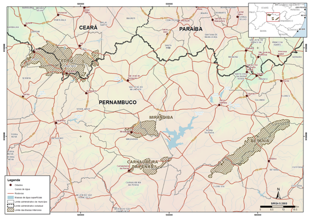
The four sedimentary
basins location
These numerical models were part of a much comprehensive study, carried out
by the consortium partner, COSTA, which included: geological and
hydrogeological characterization; wells inventory, groundwater levels monitoring
and water abstractions survey; socioeconomic and water needs diagnosis;
definition of strategic areas for drilling future stratigraphic wells and
piezometers; geophysical studies using gravimetry and vertical electrical
surveys; pumping tests; definition of hydrodynamic parameters; hydrogeological
balances; proposition and elaboration of management and investment plans for
the studied aquifers.
LNEC was also responsible for estimating groundwater recharge by rainwater
infiltration, hydrogeochemical, isotope and vulnerability to pollution analysis,
and to develop and fill in a database with the most relevant hydrogeological
information.
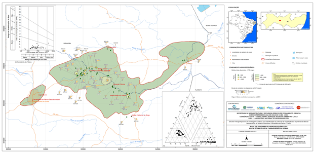
Hydrogeochemical map of the Carnaubeira da Penha
sedimentary basin
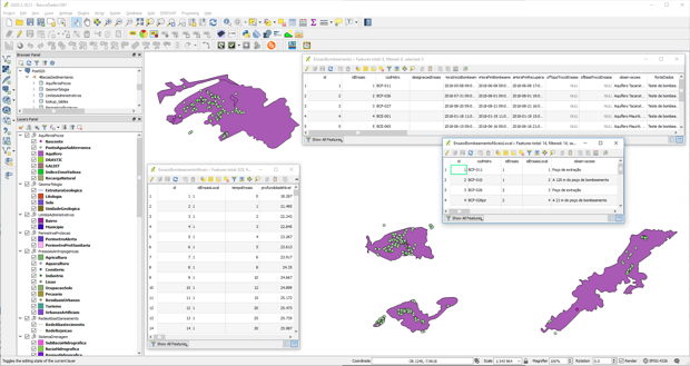
QGIS PostrGres/PostGIS database visualisation
and filling in
The numerical models were conceptualized and built
with the information obtained during the project development, using the
platform FREEWAT (http://www.freewat.eu/), an open and free source code that
integrates, also in an open source geographical information system QGIS, the
finite difference numerical model code MODFLOW and the related groundwater flow
and transport modelling software and surface water interaction programs.
Depending
on the recharge / groundwater abstraction budget, a numerical model was developed
for each sedimentary basin, in steady state for the Betânia and Carnaubeira da
Penha basins, and, due to the negative balances, in transient state for the
Mirandiba and Cedro basins. The models were calibrated using the groundwater
levels monitored during the project; for transient models, previously measured
levels were also used. The conceptual model was similar in all sedimentary
basins: natural recharge is the only form of water input into the system, while
natural discharge occurs to the intermittent watercourses existing in the
basins, which were modelled with the drain boundary condition, and artificial
discharge occur by well’s abstraction of groundwater. The (hydro)geological
formations geometry and knowledge acquired during the project led to the
definition of models with two or three layers, all reversible type, being able
to assume the condition of phreatic or confined aquifer.
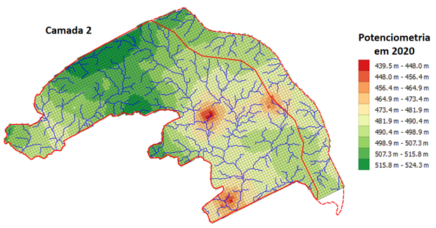
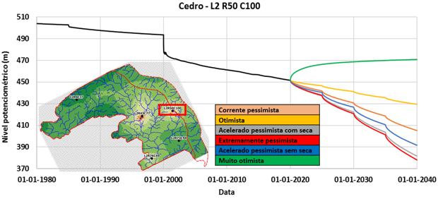
Cedro basin
groundwater head obtained for the current situation (transient state run from
1980 to 2020)
Following numerical models calibration, the
socio-economic development scenarios were modelled, all them leading to an
increase of groundwater abstraction. The obtained results allowed conclusions
to be drawn about the feasibility of these socio-economic development
scenarios.
Groundwater levels’ evolution in a specific
model cell of the Cedro basin since 1980 until now and future evolution as a
function of the exploitation scenarios
LNEC
HYDRAULICS AND
ENVIRONMENT DEPARTAMENT
Manuel M. Oliveira
Teresa E. Leitão
Tiago A. N. Martins
Ana Cristina Mendes
Joana Costa Teixeira
Maria José Henriques
Ricardo S. Lourenço
 Hydraulics and Environment Department