 Hydraulics and Environment Department

 The number of accidental oil spills affecting the Atlantic coast of
Europe in the last decades, has led to a growing concern regarding oil
spill preparedness and response, and has motivated the development and
implementation of different tools to be used in these emergency
situations.
The number of accidental oil spills affecting the Atlantic coast of
Europe in the last decades, has led to a growing concern regarding oil
spill preparedness and response, and has motivated the development and
implementation of different tools to be used in these emergency
situations. Close to shore, most damage occurs in sheltered bays and inlets, where oil becomes concentrated. In the last years different nationals and internationals administrations have promoted environmental directives aimed to the protection of these aquatic ecosystems (e.g. Water Framework Directive (2000/60/CE); Marine Strategy Framework Directive (MSFD)).
To fulfill the aforementioned legislation and to prevent, prepare for, and respond to oil spills, two different approaches exist. On one hand, planning tools to promote an integrated and sustainable oil spill response capability in the regions are needed. On the other hand, operational oceanography systems that provide real-time forecast of oceanographic variables and oil spill trajectories are becoming a key element in oil spill response. Both approaches are usually based on monitoring and numerical (hydrodynamic and transport) models. In this sense, although noticeable advances have been done in modelling at a regional scale (O(km)), there is a lack of systems to be applied at local scales such as estuarine environments or ports (O(m)). More research is needed on solving small scale processes that affect the oil spill tr ansport and fate and on methodologies and techniques for developing downscaling methods to obtain local-scale atmospheric and oceanographic conditions from variables that are provided by regional-scale models.
The main aims of this project are, therefore, to: (i) develop a set of high resolution operational oceanographic systems in s everal estuaries or ports located in the Atlantic Area, and (ii) establish local oil spill response plans for these local areas based on risk as assessment.
The main aims of this project are, therefore, to: (i) develop a set of high resolution operational oceanographic systems in s everal estuaries or ports located in the Atlantic Area, and (ii) establish local oil spill response plans for these local areas based on risk as sessment. To achieve these goals the project include the following activities which are defined in much more detail in Section 5: (1) preparation, (2) project management, (3) development of a set of high resolution operational oceanographic systems, (4) development of a set of high resolution operational oil spill forecast systems, (5) development of a risk assessment system, (6) development of local oil spill response plans and (7) a communication plan. In order to manage and distribute the work, some of the partners will lead specific activities due to their wide experience in a concrete field. Nevertheless, they will count on with the collaboration of one or more of the other partners depending on their skills.
This work will apply to estuaries and ports all along the European Atlantic coast region. The project partners have been chos en to represent the full range of coastal and hydrological conditions. The methodologies and techniques developed will be applied to sites with physical, biological and socio-economical characteristics that make them highly vulnerable to oil spill.
The aforementioned objectives fit the Priority 2 (Protect, secure and enhance the marine and coastal environment sustainability), Objective 2.1 (Improve maritime safety), of the Atlantic Area Operational Programme. This project creates a transnational multi-disciplinary co-operation across 8 main project partners of four countries of the Atlantic Area (Spain, Portugal, France and United kingdom), with the aim of addressing common problems and solutions regarding the protection of the marine resources against oil spill. A combined effort between the partner countries will allow achieving a much greater progress than separate country actions, thus establishing common standard that will contribute to the improvement of interconnections between territories.
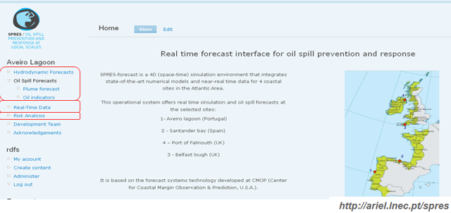
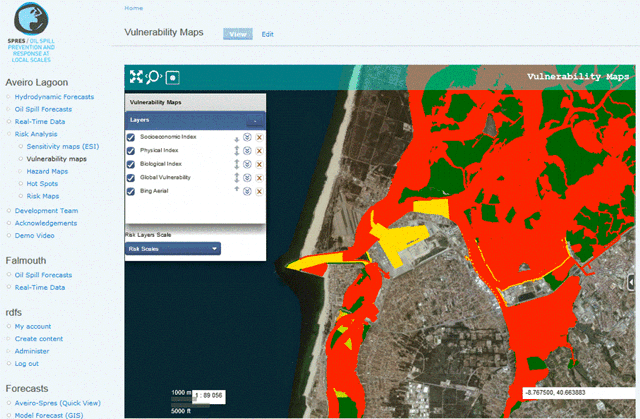
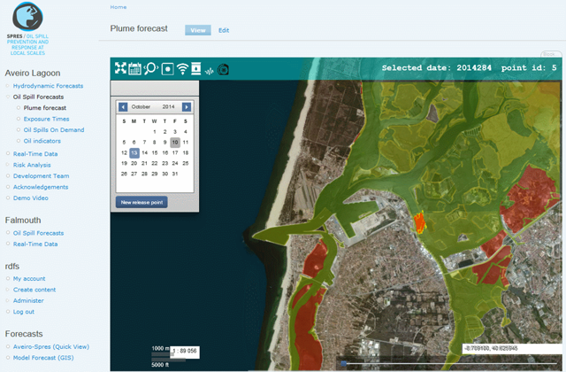
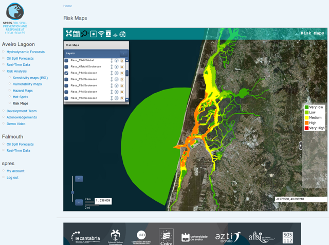
Some of the expected project benefits or outcomes will be the following: (i) future work lines for involved searchers, (ii) establishment of standardized methodologies and techniques for building up systems to protect the estuaries‟ resources along the Atlantic Area against oil spill impact, (iii) development of specific tools: (iiia) a set of high resolution operational oceanographic systems in several estuaries. These systems will provide daily forecast of sea level, currents, temperature and salinity, (iiib) oil spill modelling systems coupled with the aforementioned operational systems ready to be used at these local scales in case of pollution threat, (iiic) a GIS-based risk assessment system for each of the chosen sites, (iiid) a local oil spill response plan for each of the chosen sites, (iiie) a set of strategies for shoreline c leanup affected by oil spills.
One of the main aims of SPRES is to embed the project results firmly in regional development activities, through the involvement of stakeholders in a large range of activities as outlined in Section 7. The stakeholders will therefore be involved in the planning and delivery of the project aims, as well as promoting the project results to the wider industrial and public sector communities. By involving stakeholders closely and making sure that the stakeholder community as a whole is benefiting from the output of SPRES, this project will carry on benefiting: (i) the project partners as a base for other projects, (ii) governments, by providing decision making tools, and (iv) other stakeholders by promoting sustainable development of marine resources (see Section 7 for more details of open perpetuation plan).
Effective communication and dissemination of the project outcomes to a range of targeted audiences, including the engagement of the wider community is one of the priorities of the project. This will include an interactive website will also be part of the dissemination plan, complemented by: (i) an internet forum, (ii) regular project meetings and seminars, (iii) publications in peer reviewed journals and conference proceedings and (iv) demonstration activity and training development module, which will allow all outputs of the project to be evaluated under real time circumstances; this in turn will provide a genuine indicator, quality control and evaluation measure for assessing the final outputs.
Translation of any of these outcomes will be provided where required (see Section 11 for full details).
Although the core partners are research institutes, the match funders and sponsors include regional, government and environmental authorities.
The stakeholders will contribute in ensuring that the results and findings are taken up by end users.
Selected results


Publications
- den Boer, S., Azevedo, A., Vaz, L., Costa, R., Fortunato, A.B., Oliveira, A., Tomás, L.M., Dias, J.M., Rodrigues, M., 2014. Development of an oil spill hazard scenarios database for risk assessment. In: Green, A.N. and Cooper, J.A.G. (eds.), Journal of Coastal Research, Special Issue No. 66, pp. 539-544, ISSN 0749-0208.
- Oliveira, A., Jesus, G., Gomes, J.L., Rogeiro, J., Azevedo, A., Rodrigues, M., Fortunato, A.B., Dias, J.M., Tomas, L.M., Oliveira, E.R. Alves, F.L., den Boer, S., 2014. An interactive WebGIS observatory platform for enhanced support of coastal management. Journal of Coastal Research, Special Issue No. 66, pp. 507-512, ISSN 0749-0208.
- Jesus, G., Anabela Oliveira, António Casimiro, 2014. Ensuring Reliable Measurements In Remote Aquatic Sensor Networks, 11th International Conference on Hydroinformatics, HIC 2014, New York City, USA, 8 pages.
- Azevedo, A., S. den Boer, Gonçalo Jesus, , João L. Gomes, João Rogeiro, Anabela Oliveira, Marta Rodrigues, André B. Fortunato. 2014. WIFF – Oil spill forecast framework: application to the Aveiro lagoon, 13th International Workshop on Multiscale (Un)-structured mesh numerical ocean modeling.
- Jesus G., Gomes J., Ribeiro N.A., Oliveira A. 2012. Custom deployment of a Nowcast-forecast information system in coastal regions Geomundus, 2012.
- Gonçalo Jesus, António Casimiro, Anabela Oliveira 2013, Towards dependable measurements in coastal sensors networks, EWDC.
- Alberto Azevedo, Sérgio den Boer, Gonçalo Jesus, João Gomes, Anabela Oliveira , André B. Fortunato. 2013. Sistema computacional de alta resolução para planeamento e resposta a derrames de hidrocarbonetos em aplicações oceânicas, costeiras e estuarinas, VII Congresso sobre Planeamento e Gestão das Zonas Costeiras dos países de expressão portuguesa.
- J.L. Gomes, G. Jesus, M. Rodrigues, J. Rogeiro, A. Azevedo e A. Oliveira. 2013. Managing a Coastal Sensors Network in a Nowcast-forecast Information System, in press in the proceedings of the Sixth International Workshop on Next Generation of Wireless and Mobile Networks (NGWMN-2013)
Anabela Oliveira, Alberto Azevedo, André Fortunato, Gonçalo de Jesus, João Gomes, Marta Rodrigues, Elsa Alves e Luís Portela
For more information
« return