 Departamento de Barragens de Betão
Núcleo de Geodesia Aplicada
Publicações
|
Artigos de Revista
Info
Comparative analysis of MT-InSAR algorithms supported by GNSS data and corner reflectors: Assessing performance and accuracy

This paper presents a comparative analysis of Multi-Temporal Interferometric Synthetic Aperture Radar (MT-InSAR) algorithms in a corner reflector located in Lisbon, Portugal. The reflector was monitored using daily observations from the Global Navigation Satellite System (GNSS) technique with submillimeter precision. The study focuses on comparing the performance and accuracy of different MT-InSAR approaches i) the Persistent Scatterer Interferometry (PSI) method using the open-source software StaMPS, ii) the PSI method using the commercial software SARPROZ, iii) the Quasi-PS method implemented with the SARPROZ software, as well as iv) a hybrid method Persistent scatterer
Ano: 2024
Número Páginas:
7p..
Autor(es): Diaz, A.; Roque, D.; Solla, M.; Lima, J. N.
Revista: Procedia Computer Science
Editor: Elsevier
Volume:
239.
Keywords: Corner reflector; Accuracy; GNSS; QPS; PSI
Info
SARClust
Interferometric Synthetic Aperture Radar (InSAR) has proved its efficiency for displacementmonitoring in urban areas. However, the large volume of data generated by this technology turnsthe retrieval of information useful for structure monitoring into a big data problem. In this study, anew tool (SARClust) to analyze InSAR displacement time series is proposed. The tool performs theclustering of persistent scatterers (PSs) based on dissimilarities between their displacement time seriesevaluated through dynamic time warping. This strategy leads to the formation of clusters containingPSs with similar displacements, which can be analyzed together, reducing data dimensionality, andfacilitating the identification of displacement patterns potentially related to structural damage. Aproof of concept was performed for downtown Lisbon, Portugal, where ten distinct displacementpatterns were identified. A relationship between clusters presenting centimeter-level displacementsand buildings located on steep slopes was observed. The results were validated through visualinspections and comparison with another tool for time series analysis. Agreement was found inboth cases. The innovation in this study is the attention brought to SARClust
Ano: 2023
Número Páginas:
19p..
Autor(es): Roque, D.; Falcão, A. P.; D. Perissin; Amado, C; Lemos, J. V.; Fonseca, A. M.
Revista: Sustainability
Editor: MDPI
Volume:
15.
Keywords: Dynamic time warping; Hierarchical clustering; RADAR interpretation; InSAR; Structure monitoring
Info
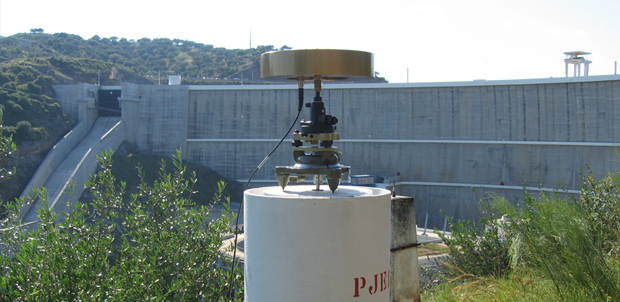
Integrated InSAR and GNSS monitoring subsystem for an arch dam and reservoir banks
Interferometric synthetic aperture radar (InSAR) is a cost-effective method for displacement measurement at dams and reservoir banks, and is especially relevant for structures without embedded equipment or rarely monitored. However, the lack of redundant observations prevents the determination of a posteriori variances for InSAR measurements, which limits the uptake of the InSAR technology for structure monitoring. This paper presents a methodology for the integration of persistent scatterer interferometry (PSI) and Global NavigationSatellite System (GNSS) displacement measurements. Double differences between PSI and GNSS data are used as observations in a redundant network connecting the points of interest, with GNSS data used to constrain PSI measurements. This procedure allows the determination of adjusted displacements and a posteriori variances at all network points. Maximum uncertainty of 3 mm was achieved for displacementsalong the SAR sensor line-of-sight at both the dam and its surrounding slopes. The proposed method is of interest for monitoring purposes, because it allows displacement measurement at both the structure and its surroundings, together with the displacement uncertainty, which aids decision makers in the planning of maintenance operations for the whole area influenced by the dam.
Ano: 2021
Número Páginas:
12p.
Autor(es): Roque, D.; Lima, J. N.; D. Perissin; Falcão, A. P.; Lemos, J. V.; Fonseca, A. M.
Revista: Journal of Surveying Engineering
Editor: American Society of Civil Engineers
Volume:
147(3).
Keywords: Uncertainty assessment; Slope; Dam; GNSS; InSAR; Data integration; Monitoring system
Info
Analysis of periodicities in long-term displacement time series in concrete dams
The hydrostatic-season-time (HST) model is a widely used method in the safety assessment of dams and for the estimation of reversible and irreversible deformations due to different load scenarios. After implementing an optimal HST-model to observational data, the residual time series can still expose some underlying periodicities. In our contribution, the underlying periodicities and their contribution to residual minimisation are further analysed by the Lomb
Ano: 2019
Autor(es): Gamse, S.; Henriques, M. J.; Oberguggenberger, M.; Mata, J.
Revista: Journal Structural Control and Health Monitoring
Editor: John Wiley & Sons, Ltd.
Keywords: multiple linear regression; Lomb
Info
Points clouds and orthomosaics from photographs
The three authors of this paper work at the Applied Geodetic Division of the National Laboratory for Civil Engineering (LNEC), in Lisbon, Portugal. LNEC is a state owned research and development institution founded in 1946. It works in the various domains of civil engineering (structures, hydraulic, geotechnics, environment, materials, among others), giving it a unique multidisciplinary perspective in this field. The main goals of the LNEC are to carry out innovative research and development and to contribute to the best practices in civil engineering.The Applied Geodetic Division nowadays develops works in two domains: the geodetic surveying of large dams and other engineering structures for monitoring purposes, and the processing of digital images with applications in several domains, which includes the study of the evolution of pathologies in engineering works. Originally the processing of digital images made use mostly of the chromatic information included in the images (from satellite images to close range photographs). But recently it has evolved to extract information of the geometry of the objects by the generation of point clouds. This use of close range photographs (from distances of decimetres to a few meters), which started in the summer of 2014, looks very promising and we, the authors, are identifying possible areas where the use of point clouds and orthomosaics that can be of interest to our colleagues of LNEC, civil engineers mostly. This paper presents the first examples where point clouds and orthomosaics, generated from close range photographs, can help civil engineers on their studies. The photogrammetic products were all generated using the free open-source software Micmac (Multi-Image Correspondances, Méthodes Automatiques de Corrélation) from IGN (Institut National de l
Ano: 2016
Número Páginas:
8p.
Autor(es): Henriques, M. J.; Roque, D.; Braz, N.
Revista: Coordinates Magazine
Editor: Coordinates Media Private Limited
Volume:
vol. 12 - Issue 9.
Keywords: Civil engineering; Structure; Monitoring; Point cloud; Orthomosaic
Info
Surveillance par drone des digues à talus
Les ports et autres infrastructures construits sur des côtes exposées à de fortes houles ont besoin d
Ano: 2016
Número Páginas:
5p.
Autor(es): Henriques, M. J.
Revista: XYZ
Editor: Association Francaise de Topographie
Volume:
148.
Keywords: Digue; Drone; Oscultation
Info
Using simplified bathymetry and SAR imagery in the validation of a hydraulic model for the Tagus River floodplain
This work presents several approaches in the validation of the hydrodynamic model Tuflow on the simulation of flood extents and water levels, based on satellite SAR imagery. A methodology that uses a simplified bathymetry in the river main course is employed, which proves to be reliable and accurate for high-flow events. This was made possible as the digital terrain model was acquired in a dry period, accounting for large dry areas in the river bed, avoiding in this way the need of expensive river bathymetry surveys. Also, two methods are applied to the SAR imagery to extract the flood boundaries: visual interpretation followed by manual delimitation and an object-based algorithm approach. The hydraulic model is tested on a reach of the Tagus River, Portugal, where the largest flood inundation areas occur, using a historical flood event to verify its robustness and reliability. The accuracy of model prediction is done through comparisons of water levels at a hydrometric station and the determination of commission and omission errors of flood extent, between the reference SAR image and the predicted inundation. It was concluded that the methodology followed in this work is well suited for the hydraulic model validation.
Ano: 2016
Número Páginas:
5p.
Autor(es): Araújo, M. A. V. C.; R. Pestana; M. Matias; Roque, D.; Teixeira, A.; Heleno, S.
Revista: Journal of Coastal Research
Editor: Coastal Education & Research Foundation
Volume:
75.
Keywords: Tuflow; Commission and omission errors; SAR imagery; Simplified bathymetry
Info
Port infrastructure control (Madeira Island, Portugal) through a hybrid monitoring system (GNSS and Accelerometers)
This article describes the implementation of a monitoring system on the breakwater at the Funchal Port (Madeira Island, Portugal) for the purpose of understanding its dynamic behavior and the temporal evolution of structural health. The monitoring system focuses on the breakwater superstructure and aims to identify the evolution of damage on the breakwater and analyze the impact of cruise ships docking and undocking. The system includes the measurement of displacements through geodetic techniques using global navigation satellite systems and the measurement of vibrations using accelerometers. Ten observation campaigns were performed over almost 3 years. As the measured displacements during this period were less than 7.5 mm it can be concluded that, despite some visible cracks, the breakwater superstructure did not suffer significant structural changes. It was shown from the measured acceleration records that some of the main modal parameters could be identified, namely the main natural frequencies of the superstructure. Through an analysis of the natural frequencies progression over time, it will be possible to identify deterioration effects on the foundation and/or the superstructure. The comparison of natural frequencies identified could be useful to evaluate the impact of these events on structural health.
Ano: 2015
Número Páginas:
617-629pp.
Autor(es): Pereira, Mário; Teodoro, A.; Lima, J. N.; Oliveira, S.; Gomes, F.V.
Revista: Journal Marine Georesources & Geotechnology
Editor: Taylor & Francis Group
Volume:
Volume 34, 2016 - Issue 7.
Keywords: Port; Docking/undocking; Breakwater; Accelerometers; GNSS
Info
Fusão de deslocamentos medidos com o GNSS e acelerações
A fusão de dados provenientes de diferentes tipos de instrumentos pode dar uma informação mais completa para a monitorização do comportamento de estruturas de engenharia civil, em particular nas pontes de grande vão. O objectivo da fusão de deslocamentos medidos com o GNSS e de acelerações, é tirar partido da precisão conseguida com o GNSS, em baixas frequências, e da grande sensibilidade dos acelerómetros, em altas frequências, e obter uma única série temporal de deslocamentos, longa e de grande resolução. Através dum filtro de Kalman será possível integrar deslocamentos medidos, com uma frequência de amostragem de, por exemplo, 1 Hz, e acelerações medidas, com uma frequência de amostragem de, por exemplo, 100 Hz, de modo a obter uma série temporal de deslocamentos de longa duração e com uma resolução de 100 Hz. Nesta comunicação apresentam-se os resultados preliminares dum ensaio realizado num modelo estrutural simples correspondente a um edifício de três pisos, instrumentado com antenas GNSS da Topcon e acelerómetros da Kinemetrics, modelo Episensor ES-U2, e da Nanometrics, modelo Titan SMA, tendo em vista a futura aplicação desta metodologia em pontes de grande vão.
Ano: 2013
Número Páginas:
10.
Autor(es): Lima, J. N.; Oliveira, S.; Henriques, M. J.
Revista: 3 ASCP, Actas do 3º Congresso da Associação Portuguesa para a Segurança e Conservação de Pontes
Editor: Associação Portuguesa para a Segurança e Conservação de Pontes
Keywords: Fusão; Acelerómetros; Monitorização; Pontes; Gnss
Info
SMOOTHING GNSS TIME SERIES WITH ASYMMETRIC MOVING AVERAGES
There is an increasing trend to apply GNSS continuous observation of short baselines to the monitoring of engineering works, such as bridges and dams, for their structural analysis and safety control. In the case of large dams, one important application of the GNSS continuous observation is the establishment of early warning systems that demand accurate, frequently updated information and where the analysis of the baseline time series, in order to separate signal from noise is mandatory. The paper presents a study on the performance of linear filters of the asymmetric moving average (AMA) type to smooth baseline time series. The transfer function of the AMA is adopted as a smoothing criterion to define an adequate order for the AMA, in face of the spectral density function of the baseline time series. One series of measurements of a short test baseline (325 m), materialized in the campus of the National Laboratory for Civil Engineering, is used as an example of the proposed strategy.
Ano: 2012
Número Páginas:
6.
Autor(es): Lima, J. N.; Casaca, J. M.
Revista: Journal of Civil Engineering and Architecture
Editor: David Publishing Company
Volume:
Volume 6, Number 6.
Keywords: Spectral density; Signal; Noise; Moving average; Gnss
|
|
Comunicações
Info
Utilização de Informação Geográfica pelos Municípios Portugueses: Resultados de um Inquérito Nacional
O trabalho aqui apresentado resultou da análise de um inquérito, que teve como objectivocaracterizar a atitude dos serviços/departamentos autárquicos face à informação geográfica (IG).Três questões basilares orientaram a sua elaboração: A IG é usada regularmente? Constitui umrecurso importante? Os seus atributos espaciais e temporais são apropriados à actividade municipal?Analisando as respostas a estas questões, pretendeu-se avaliar a utilidade e valor da IG, bem comoanalisar as prioridades e perspectivas do governo local em matéria de dados geográficos.O universo estatístico foi constituido por 308 Municípios. A taxa de resposta foi de 45%, com 128respostas em Portugal Continental, 3 na Região Autónoma da Madeira e 9 na Região Autónoma dosAçores, perfazendo um total de 140 inquéritos preenchidos e validados.Os resultados permitiram concluir: i) que os tipos de utilização da IG são fortemente dependentes dotipo de serviços; ii) que a actualização de IG é particularmente importante por efeito da Lei; iii) quea introdução de dados orbitais de alta resolução espacial nos processos de actualização de IG é aindapouco frequente.
Ano: 2011
Autor(es): Santos, T.; Tenedório, J.; Freire, S.; Fonseca, A. M.
Editor: Ingenium- Ordem dos Engenheiros
Keywords: Inquérito; Municípios; Informação geográfica
Info
A Comparação de Distribuições Anteriores Alternativas em Modelos Bayesianos
A comunicação apresenta um critério numérico Bayesiano - o Factor de Bayes - para comparar o mérito de distribuições alternativas, com base nas correspondentes distribuições preditivas anteriores.
Ano: 2010
Autor(es): Casaca, J. M.; Piteira Gomes, J.
Editor: LNEC - DE
Keywords: Hiper-parâmetro; Factor de bayes; Eliciação
Info
A relevância do contexto e heterogeneidade urbanos na extracção de elementos em imagens QuickBird
O trabalho que aqui se apresenta tem lugar no âmbito do projecto GeoSat, em curso, que visa explorar o potencial das imagens de satélite de alta resolução espacial para extrair informação geográfica e actualizar cartografia existente para apoio às actividades dos municípios. Neste contexto, testam-se metodologias para extracção de edifícios de tipologias diversas em áreas da cidade de Lisboa com diferentes características, caracterizadas com recurso a métricas espaciais, e investiga-se o impacto da heterogeneidade destes elementos e do contexto urbano no processo de extracção
Ano: 2010
Autor(es): Freire, S.; Santos, T.; Fonseca, A. M.; Tenedório, J.; Gomes, A.
Keywords: Quickbird
Info
Apoio geodésico à construção de um túnel rodoviário
Na presente comunicação descreve-se o apoio dado pelos métodos Geodésicos ao acompanhamento da abertura e monitorização do túnel rodoviário que está a ser construído no Marão, um túnel que terá 5.6 km de extensão. A abertura de túneis com uma extensão de vários quilómetros, exige um acompanhamento da Geodesia Aplicada, de modo a serem respeitados os níveis de precisão desejáveis. Os critérios geodésicos devem intervir no estabelecimento das redes de apoio exterior e interior, necessárias para definir a orientação da escavação e na monitorização de convergências e assentamentos do túnel. As redes de apoio exteriores, necessitam de metodologias geodésicas de observação e de processamento dos dados que assegurem incertezas reduzidas. Relativamente à monitorização, a obtenção de resultados com incerteza milimétrica ou mesmo submilimétrica, exige também cuidados especiais, tanto na concepção, como na materialização do sistema e, também, durante a observação.
Ano: 2010
Número Páginas:
10.
Autor(es): Henriques, M. J.; Lima, J. N.; Casaca, J. M.
Editor: LNEC
Keywords: Gnss; Taqueometria; Túnel; Monitorização; Geodesia
Info
Cartographic data extraction from airborne imagery by hierarchical-based morphologic image processing
This paper presents a comprehensive approach to effectively extract cartographic urban data from high resolution satellite imagery. Itconsists of a sequence of image processing techniques, for image segmentation, based on RGB band separation, analysis and preprocessing,followed by a morphological-based approach for data segmentation. The chosen image objects for this study are roof-tilebuildings and road network. The first step of this approach consists of a spectral response evaluation for roof-tile building objects ina dense urban environment, being those enhanced through proper sequence of standard arithmetic operators, applied to RGB bands,segmented and generalized. The second step aims at urban road network segmentation for cartographic representation purposes, bycombining watershed and dual reconstruction morphological transformations, which characterize the hierarchical waterfall concept.For the latter concept, a new approach is developed in order to improve hierarchical segmentation procedure, to better induce objectdiscrimination. Each one of the referred objects will be segmented in separate. The road network segmentation will have inconsideration the previous result of roof-tile buildings extraction. Finally, segmented objects will be compared with other extractionresults in order to do proper validation. The method is applied over high-resolution ortho-rectified images, taken from satellite, of thecity of Lisbon. Results will show the practicality of the method for purposes of cartographic data structures acquisition, from highresolutionsatellite imagery, aiming urban management and GIS applications.
Ano: 2010
Autor(es): Soares, F.; Navarro, A.; Santos, T.; Freire, S.; Fonseca, A. M.; Afonso, N.; Tenedório, J.
Editor: GEOBIA
Keywords: Waterfall segmentation; Watershed segmentation; Feature extraction; Hierarchical segmentation
Info
Detecção de alterações em meio urbano baseada na comparação de elementos extraídos a partir de imagens de alta resolução espacial. Aplicação à área da Alta de Lisboa
No presente trabalho, a classificação temática das imagens realiza-se ao nível do elemento. A experimentação teve como objectivo a extracção automática de elementos de interesse municipal para detecção de alterações. Dos elementos com maior relevância para a actualização cartográfica de bases de dados municipais podem-se distinguir os edifícios, as vias de comunicação e áreas verdes. Numa área urbana com elevada dinâmica como a do concelho de Lisboa, a informação actualizada sobre o edificado é necessária para dar cumprimento aos pedidos de licenciamento, à emissão de licenças de construção ou para emissão de plantas. Actualmente, a cartografia municipal é actualizada durante a fase de revisão do Plano Director Municipal (PDM), o que acontece geralmente todos os 10 anos, por imposição legal. Porém, muitas vezes este período é superior (e.g., o actual PDM de Lisboa data de 1994), o que conduz a um grande desfasamento entre as bases de dados cartográficas e a realidade.
Ano: 2010
Autor(es): Santos, T.; Freire, S.; Fonseca, A. M.; Tenedório, J.
Keywords: Detecção de alterações; Quickbird
Info
Extracção de edifícios em Lisboa com imagens QuickBird e dados LiDAR
No âmbito do projecto GeoSat, a aplicação Feature Analyst é testada para extracção automática de elementos ao nível municipal a partir dados espectrais e altimétricos numa área de estudo localizada em Lisboa.A metodologia apresentada baseia-se na extracção semi-automática de features, tendo por base informação proveniente de uma imagem QuickBird e de dados LiDAR. A imagem QuickBird permite delimitar os diferentes elementos à superfície com base no seu comportamento espectral. Porém, esta tarefa é tanto melhor sucedida quanto mais rica for a informação auxiliar utilizada no processo de extracção. Assim, com a introdução de dados LiDAR, pretende-se estudar o efeito da contribuição desta informação no processo de classificação de dados orbitais.Os resultados obtidos mostram que a introdução da informação altimétrica, no conjunto de dados espectrais, permite uma melhoria na qualidade da informação extraída por meios semi-automátcios.
Ano: 2010
Autor(es): Santos, T.; Freire, S.; Tenedório, J.; Fonseca, A. M.
Editor: USIG
Keywords: Quickbird; Lidar
Info
Extracting buildings in the city of Lisbon using Quickbird images and lidar data
The methodology is based on semi-automatic extraction of features, using information from a QuickBird image and LIDAR data.The QuickBird image is suitable to delineate the different elements on the surface based on their spectral characteristics. However,this task is much more successful and richer when altimetric information is also used in the extraction process. Thus, with theintroduction of LIDAR data, we intend to study the effect of the contribution of information on the height of urban elements, whenclassifying orbital data. The thematic information under analysis is the land cover class Buildings.Two maps are produced and compared. One map is obtained by a classification based only on spectral data while the other map isobtained using spectral and altimetric data. The same methodology is applied in both scenarios, using the same training features. Toevaluate the quality of the two maps, a comparison with a cartographic layer is carried out. This reference layer is obtained by visualanalysis of the QuickBird image and is used to calculate the Overall Accuracy of the maps obtained with the different data sets.
Ano: 2010
Autor(es): Santos, T.; Freire, S.; Navarro, A.; Soares, F.; Dinis, J.; Adriano, P.; Fonseca, A. M.; Tenedório, J.
Editor: GEOBIA
Keywords: Accuracy assessment; Feature extraction
Info
Extraction of buildings from QuickBird imagery for municipal planning purposes: quality assessment considering existing mapping standards
Many municipal activities require updated large-scale maps that include both topographic and thematic information. For thispurpose, the efficient use of very high spatial resolution (VHR) satellite imagery suggests the development of approaches that enablea timely discrimination, counting and delineation of urban elements according to legal technical specifications and quality standards.Therefore, the nature of this data source and expanding range of applications calls for additional methods and metrics to assess thequality of the extracted information which go beyond traditional thematic accuracy alone. The present work concerns the feasibilityof VHR satellite imagery as an alternative source of geospatial information for large scale mapping to assist urban planning inPortugal. Feature extraction software was employed to map buildings present in a pansharpened QuickBird image of Lisbon. Qualityassessment was exhaustive and involved comparisons of extracted features against a reference dataset, introducing cartographicconstraints from scales 1:1000, 1:5000, and 1:10000. The spatial data quality elements subject to evaluation were: thematic(attribute) accuracy, completeness, and geometric quality based on planimetric deviation from the reference. Tests were developedand metrics analyzed considering thresholds and standards for the different mapping scales most used by municipalities. Resultsshow that values for completeness varied with mapping scales and results were only slightly better for scale 1:10000. Concerning thegeometric quality, a large percentage of extracted features met the strict topographic standards of planimetric deviation for scale1:10000, while no buildings were compliant with the specification for scale 1:1000.
Ano: 2010
Autor(es): Freire, S.; Santos, T.; Navarro, A.; Soares, F.; Dinis, J.; Afonso, N.; Fonseca, A. M.; Tenedório, J.
Editor: GEOBIA
Keywords: Quickbird; Feature extraction
Info
Extraction of Buildings from QuickBird Imagery for Municipal Use
Lisbon is both a historical and modern city having a dynamic landscape, where increasingly diverse urban forms and materials coexist. This complex reality is possibly causing the feature extraction process from imagery to become more challenging. This study tests the semi-automated extraction of buildings from a QuickBird image in urban areas with different characteristics, and explores the impact of the heterogeneity of these features in the extraction process. Spatial metrics are used to characterize types of buildings present in the study areas. Results show that the study areas display different levels of heterogeneity even for the same type of building and suggest that the extraction may be affected by the spatial configuration of target features.
Ano: 2010
Autor(es): Freire, S.; Santos, T.; Fonseca, A. M.; Tenedório, J.
Editor: EARSEL
Keywords: Spatial metrics; Feature extraction; Quickbird
|
|
Livros
Info
História Breve do Calendário
O calendário Gregoriano não é mais do que uma reforma do calendárioJuliano, devido a Júlio César, que adaptou os formalismos romanos a uma antigaestrutura solar de origem egípcia. Este ensaio descreve a história do calendárioGregoriano e dos calendários da bacia do Mediterrâneo e do Oriente Próximo,com ele mais ou menos aparentados.
Ano: 2009
Número Páginas:
61pp.
Autor(es): Casaca, J. M.
Editor: LNEC
Keywords: Calendários
|
|
Teses de Doutoramento
Info
Displacement measurement through InSAR geodesy for structural health monitoring
Interferometric synthetic aperture RADAR is an applied geodesy technique, which enables displacement measurement through satellite images. A literature review of the technique principles and of previous studies regarding its application to structural health monitoring allowed the identification of a few bottlenecks to the operational usage of this cost-effective technology for monitoring purposes.Three research lines were defined. First, a data mining strategy was developed to extract structural behaviour information from displacement time series from thousands of points on the region of interest, with tens of observation epochs each. Second, displacements from this technique were integrated into a previously existing monitoring system and were used to expand it to a larger number of points on the structure and to its surroundings. Third, an experimental infrastructure was deployed in order to perform several tests for displacement validation and uncertainty assessment. The infrastructure included a new model of artificial reflector to the satellite signals, purposefully developed in the scope of this study.The developed methods enabled the successful monitoring of different types of civil and geotechnical structures. Slope behaviour around water reservoirs was assessed during both the reservoir first impoundment and regular operation. Differential displacements were detected on building-blocks at a cultural heritage urban area and concrete arch dam responses to temperature loads were identified. The experimental work showed the achieved displacements agreed with those of other geodetic techniques and uncertainties around 2 mm were obtained for the measurements.In conclusion, interferometric synthetic aperture RADAR is a promising technique, able to provide useful information for structure monitoring, such as aiding in the planning of in situ monitoring activities and in identifying space-time patterns in structural behaviour. Thanks to its spatial coverage, observation period of a few days and achieved displacement uncertainty, it is advantageous to complement existing monitoring systems with data from this technique.
Ano: 2020
Autor(es): Roque, D.
Keywords: Uncertainty analysis; Data mining; Interferometric synthetic aperture RADAR; Geodesy; Structure monitoring systems
|
|
Relatórios
Info
ImEngine
Neste relatório apresenta-se, de forma sucinta, a atividade de investigação realizada no âmbito do projeto ImEngine no período 2014-2023. Os resultados da atividade são analisados e avaliados, em face dos objetivos inicialmente previstos.
Ano: 2023
Autor(es): Fonseca, A. M.; Henriques, M. J.; Roque, D.
Keywords: Drone; Inspeção visual; ImEngine; IVisA; Deteção de alterações; Reconhecimento de padrões; Processamento digital de imagens; Imagem numérica
Info
INFRASAR
Neste relatório apresenta-se, de forma sucinta, a descrição da atividade de investigação realizada no âmbito do projeto INFRASAR no período 2014-2023. Os resultados da atividade são analisados e avaliados, em face dos objetivos inicialmente previstos.
Ano: 2023
Autor(es): Fonseca, A. M.; Roque, D.
Keywords: Deteção de deslocamentos; Difusores permanentes; INFRASAR; PSInSAR; Interferometria SAR
Info
MEGA
Neste relatório apresenta-se, de forma sucinta, a descrição da atividade de investigação realizada no âmbito do projeto MEGA no período 2015-2023. Os resultados da atividade são analisados e avaliados, em face dos objetivos inicialmente previstos.
Ano: 2023
Autor(es): Lima, J. N.
Keywords: Séries temporais; GNSS; Análise Bayesiana; MEGA
Info
MOSAIC.pt
Este relatório apresenta os procedimentos do levantamento fotogramétrico, realizado com um drone, assim como as ações complementares, destinados a obter informação de carácter geométrico da praia da Cova Gala em 2020. Este documento inclui ainda uma análise da qualidade dos produtos gerados e uma comparação com o levantamento realizado em 2019, cerca de um ano antes.
Ano: 2021
Autor(es): Henriques, M. J.
Keywords: Drone; Fotogrametria; Levantamento; Praia da Cova Gala
Info
Base das Lajes - Resultados do nivelamento geométrico de precisão realizado em outubro de 2020, nos pontos de monitorização da qualidade das águas subterrâneas
Este relatório apresenta os resultados da campanha de nivelamento geométrico das bocas de furos de captação de água na proximidade da Base das Lajes, realizada pelo Núcleo de Geodesia Aplicada do Departamento de Barragens de Betão do LNEC, em outubro de 2020. Os resultados são as cotas, numreferencial local, das bocas dos furos de captação de água.
Ano: 2020
Autor(es): Candeias, H.; Fonseca, A. M.
Keywords: Furos de captação de água; Nivelamento geométrico; Base das Lajes
Info
MOSAIC.PT
Este relatório apresenta os procedimentos dos levantamentos fotogramétricos, realizados com um drone, assim como as ações complementares, efetuadas em 2019, destinados a obter informação de carácter geométrico das praias de Cova - Gala, Vieira e São Pedro de Moel.
Ano: 2020
Autor(es): Henriques, M. J.
Keywords: Drone; Fotogrametria; Levantamento; Praia
Info
ImEngine
Neste relatório apresenta-se, de forma sucinta, a atividade de investigação realizada no âmbito do projeto ImEngine no período 2014-2017. Os resultados da atividade são analisados e avaliados, em face dos objetivos inicialmente previstos, sendo proposta uma extensão do projeto, e respetiva revisão do plano de atividades, para os próximos dois anos.
Ano: 2018
Autor(es): Fonseca, A. M.; Henriques, M. J.; Roque, D.
Keywords: Drone; Inspeção visual; ImEngine; IVisA; Deteção de alterações; Reconhecimento de padrões; Processamento digital de imagens; Imagem numérica
Info
INFRASAR
Neste relatório apresenta-se, de forma sucinta, a descrição da atividade de investigação realizada no âmbito do projeto INFRASAR no período 2014-2017. Os resultados da atividade são analisados e avaliados, em face dos objetivos inicialmente previstos, sendo proposta uma extensão do projeto e revisão do plano de atividades para os próximos dois anos.
Ano: 2018
Autor(es): Fonseca, A. M.; Roque, D.
Keywords: Deteção de deslocamentos; INFRASAR; Difusores permanentes; PSINSAR; RADAR; Interferometria; Processamento digital de imagens
Info
MEGA
Neste relatório apresenta-se, de forma sucinta, a descrição da atividade de investigação realizada no âmbito do projeto MEGA no triénio 2015-2017. Os resultados da atividade são analisados e avaliados, em face dos objetivos inicialmente previstos, sendo proposta uma revisão do plano de atividades para os próximos dois anos.
Ano: 2018
Autor(es): Casaca, J. M.; Lima, J. N.
Keywords: Séries temporais; GNSS; Análise bayesiana
Info
Determinação de deslocamentos com geodesia InSAR para o controlo de segurança de estruturas - Plano de tese de doutoramento da bolseira Dora Roque
O relatório apresenta uma proposta de plano de estudos para a tese de doutoramento da bolseira Dora Roque, a realizar no Núcleo de Geodesia Aplicada do Departamento de Barragens de Betão do Laboratório Nacional de Engenharia Civil. O objetivo principal do estudo é contribuir para a operacionalização da geodesia InSAR na determinação de deslocamentos para o controlo de segurança de estruturas.
Ano: 2016
Autor(es): Roque, D.; Fonseca, A. M.; Lemos, J. V.; Falcão, A. P.
Keywords: Sistemas de observação; Geodesia InSAR; Plano de tese
|
|
Informações Científicas e Técnicas
Info
A distribuição do desvio padrão empírico
O trabalho aborda simultaneamente a distribuição do desvio padrão da amostra aleatória normal e a distribuição do desvio padrão do modelo de Gauss-Markov, designados genericamente por desvio padrão empírico. Após mostrar que o desvio padrão empírico é um estimador excêntrico que subestima o desvio padrão da amostra ou do modelo, conforme o caso, são apresentadas correções de excentricidade. É também tratada a estimação do desvio padrão da amostra e do modelo em cenário Bayesiano, com diferentes distribuições anteriores. O trabalho é rematado por casos de estudo baseados na simulação de amostras normais e por um exemplo concreto relacionado com o controlo da precisão de um distanciómetro eletromagnético.
Ano: 2015
Autor(es): Casaca, J. M.
Keywords: Desvio padrão
Info
A resolução de problemas mal colocados na observação geodésica de barragens
O presente trabalho apresenta uma metodologia genérica para a regularizaçãode problemas inversos lineares mal colocados e a sua aplicação às redes altimétricas eplanimétricas usadas na monitorização de deslocamentos de pontos notáveis de grandesbarragens por métodos da Geodesia Aplicada. A metodologia é ilustrada por intermédiode três casos de estudo.
Ano: 2013
Número Páginas:
39pp.
Autor(es): Casaca, J. M.
Editor: LNEC
Keywords: Observação geodésica; Observação de barragem
Info
The Beta-Binomial Model
This paper deals with the beta-binomial model, which is an important stochasticmodel within the scope of the Bayesian statistical inference. After a short review of the binomialand beta distributions, the paper presents the closed formulae for the posterior probabilitydensity function of the binomial trial parameter and for the prior predictive and forthe posterior predictive probabilities of the successes in binomial experiments. A descriptionof the Bayesian methodology to test different hyper-parameters for the conjugate priorprobability density functions of the beta family is also presented. Finally, the beta-binomialmodel is illustrated with a study case related to the quality control of the geodetic observationof large dams.
Ano: 2013
Número Páginas:
24pp.
Autor(es): Casaca, J. M.
Editor: LNEC
Keywords: Binomial distribution; Beta distribution; Bernoulli trial parameter; Bayes factor
Info
Análise de regressão multivariada - Uma perspetiva Bayesiana
O presente trabalho, além de uma revisão sintética da abordagem frequencista,trata da abordagem Bayesiana da análise de regressão linear multivariada. É apresentadauma compilação de procedimentos e fórmulas para a estimação dos coeficientes da regressão,sob três cenários de informação anterior. Finalmente, o trabalho ocupa-se dosproblemas da predição de respostas e da comparação de modelos de regressão.
Ano: 2012
Número Páginas:
47pp.
Autor(es): Casaca, J. M.
Editor: LNEC
Keywords: Estatística bayesiana; Análise de regressão; Análise multivariada
Info
The Gamma, Multi-gamma, Digamma and Trigamma Functions
The work presents the theoretical definitions of the gamma, multi-gamma, digammaand trigamma functions as well as operational approximations to compute their values.A more precise alternative, due to Robert Windschitl, to the traditional approximationof the gamma function by the Stirling
Ano: 2012
Número Páginas:
20pp.
Autor(es): Casaca, J. M.
Editor: LNEC
Keywords: Trigamma-function; Digamma-function; Multi-gamma function; Gamma functions; Windschitl approximation; Stirling
Info
Introdução à análise Bayesiana
O trabalho descreve os princípios da análise Bayesiana, usando como caso deestudo a amostra aleatória normal identicamente distribuída. Após um curto preâmbulohistórico, são resumidos, na Secção 2, os conceitos mais importantes da análise frequencista.Nas secções seguintes, são abordados os temas Bayesianos mais importantes, taiscomo a estimação, pontual e regional (Secção 5), e o teste de hipóteses sobre osparâmetros da distribuição da amostra (Secção 6). As distribuições anteriores de Laplace,Jeffreys e conjugada normal-gama invertida são apresentadas na Secção 4. O problemada eliciação paramétrica das distribuições anteriores conjugadas é tratado na Secção 7.Palavras Chave: distribuições anteriores e posteriores, divergência de Kullback-Leibler,eliciação paramétrica, factor de Bayes, fórmula de Bayes, verosimilhança.
Ano: 2011
Número Páginas:
78pp.
Autor(es): Casaca, J. M.
Editor: LNEC
Keywords: Análise bayesiana
Info
Estratégia para a Calibragem dos Distanciómetros Electromagnéticos Utilizados na Observação Geodésica de Barragens
Este trabalho define uma estratégia, apoiada o mais possível nas disponibilidades do LNEC, para a calibragem dos distanciómetros electromagnéticos (DEM) usados pelo Núcleo de Geodesia Aplicada na observação geodésica de barragens.
Ano: 2002
Número Páginas:
38.
Autor(es): Henriques, M. J.
Editor: LNEC
Keywords: Base de teste; Dem; Distanciómetros; Calibragem
|
|
Outros
Info
Integration of image processing tools for monitoring breakwaters models
N/A
Ano: 2016
Autor(es): Soares, F.; Henriques, M. J.; Braz, N.
Editor: ESA
Keywords: Quebra-mar; Monitorizaçao
|